Grays Harbor is in for a wild weather ride this week as heavy rain, river flooding, high winds, gales along the coast and a small craft advisory are all in play.
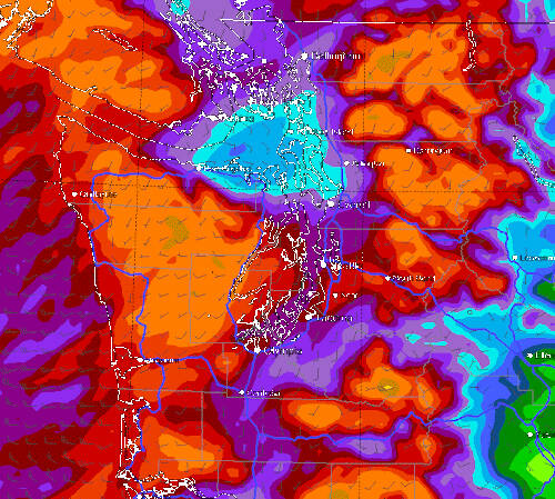
“We are about to enter a very wet period, with the potential for bankfull rivers and even some localized flooding,” said Cliff Mass (Mass is an American professor of Atmospheric Sciences at the University of Washington). “It will rain much of this week and the totals will be impressive by the time it is over, with some sodden locations getting 10 inches or more. On Tuesday, a weak ridge of high pressure moves over us, providing a break. And then a strong trough comes in on Wednesday.
Mass called it a classic November pattern.
“By Wednesday at 4 p.m., wow … with some locations up to 10 inches. And it is not over,” Mass said. “(It’s) mid-November and the atmosphere is doing what it should. Our water resources are being restored, reservoirs are refilling, and moisture is percolating down into our soils.”
River flooding
The National Weather Service in Seattle also forecast a threat of river flooding is coming this week. A series of strong and wet Pacific storm systems will track through Western Washington this week with sharp rises on the rivers flowing off the Olympics and Cascades.
There is little break between each system. As a result, several rivers are forecast to reach Action Stage with minor flooding possible, especially by Wednesday or Thursday. Flooding extent will depend on rainfall rates, temperatures, snow levels and total rainfall with each of these weather systems this week.
Progressively stronger storms earlier Monday morning continued to produce heavy rain in the Olympic Mountains. Two to four inches of rain were expected through Monday and another three to six inches Tuesday night into Thursday.
So far all Grays Harbor County rivers are forecast to be well below flood stage. The nearest river to flood is the Skokomish River in Mason County, which will crest midday Wednesday, at 17.56 feet. At 17.5 feet, traditionally the Skokomish River will cause moderate flooding, with deep and quick flood waters inundating some residential areas, many roads, and much of the farmland in the Skokomish Valley. Inundated roads include the Skokomish Valley road, Bourgault Road West, Purdy Cutoff Road and state Route 106.
Wind
Then there is the wind. A wind advisory starts at 4 p.m. Tuesday and lasts until 4 a.m. Wednesday, impacting the coast including the cities of Neah Bay, Queets, La Push, as well as Forks, Aberdeen and Hoquiam.
In Grays Harbor expect southeast winds from 25 to 35 miles per hour, with gusts up to 50 miles per hour.
Gusty winds could blow around unsecured objects. Tree limbs could be blown down and a few power outages may result.
Use extra caution when driving, especially if operating a high profile vehicle. Secure outdoor objects.
In Pacific County, the winds will be stronger, with south winds forecast 30 to 40 miles per hour, with gusts up to 60 miles per hour, from 8 p.m. Tuesday to 6 a.m. Wednesday. This High Wind Watch includes Tokeland and Raymond.
A High Wind Watch for the coastal headlands and beaches means a hazardous high wind event is possible in areas along the immediate coast. Many of the headland areas and beaches are vulnerable to very strong wind gusts that may pose a safety hazard.
The strong winds may also cause property damage. Sustained wind speeds of at least 40 mph or gusts of 58 mph or more are possible. Coastal headlands are characterized by high, rocky shores and steep sea cliffs.
Consider sleeping in a location that is furthest away from large trees and power lines. Be aware of your surroundings and where you are relative to nearby trees and powerlines.
Prepare for potential power outages. If you have a gas-powered generator, ensure you have enough fuel. Ensure you have batteries, flashlights, and a way to maintain a safe body temperature if you were to lose heating.
High surf
Along the Pacific Ocean, a High Surf Advisory was placed Monday evening and expected to last through 4 p.m. Tuesday.
Expect large waves and hazardous surf conditions and breakers up to 25 feet. Destructive waves may wash over beaches, jetties, and other structures unexpectedly. People can be swept off rocks and jetties and drown while observing high surf. Minor beach erosion may damage coastal properties and buildings. Higher than normal water run-up is expected on beaches and low lying shorelines.
A High Surf Advisory means that high surf will affect beaches, producing rip currents, sneaker waves and beach erosion. Stay well back from the water’s edge and be alert for exceptionally high waves.
Keep away from large logs on the beach. Water running up on the beach can easily lift or roll logs which can injure or kill someone caught in their path.
Small craft
The Grays Harbor coast was under a Small Craft Advisory through Tuesday at noon, with a gale watch from Tuesday afternoon through Tuesday evening.
For the Small Craft Advisory, southwest winds 15 to 22 miles per hour were forecast with seas 15 to 20 feet. For the Gale Watch, south winds 20 to 25 miles per hour were forecast, with seas 14 to 19 feet possible.
Strong winds can cause hazardous seas which could capsize or damage vessels and reduce visibility.


