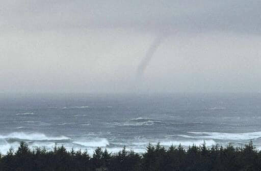
Just as the weather appeared to settle down after the bomb cyclone Tuesday evening and Wednesday morning, the National Weather Service in Seattle issued a Tornado Warning for Tokeland at about 4:45 p.m. Wednesday, followed shortly after with Grays Harbor Emergency Management stating at 5 p.m. the Tornado Warning had expired as wind circulation had weakened below severe limits.
It was a scary moment as smart phones lit up with the warning, prompting those at Walmart in Aberdeen to take cover.
Trained weather spotters spotted some weather Wednesday afternoon when they saw “a well-defined waterspout just west of the Long Beach peninsula in Washington,” according to the National Weather Service in Portland.
About an hour later the waterspout was captured on video as it continued north just offshore through Tokeland and into North Cove.
A waterspout is a swirling column of water. If it comes ashore, it becomes a tornado.
Tornadoes and waterspouts aren’t especially common in Oregon and Washington, though officials confirmed a tornado hit Rockaway Beach on the Oregon coast earlier this month.
On Tuesday, the coast began to experience a “bomb cyclone,” which brought high waves and wind.
The National Weather Service said the storm was “still capable of producing waterspouts,” noting that a tornado warning was in effect for the area until 5 p.m. Wednesday.
More stormy weather
The Grays Harbor PUD on Thursday said to watch for deteriorating conditions in the next few days.
“Tuesday was such fun, we’re going to do it again,” Grays Harbor PUD posted. “Good news, this event is not expected to be as strong as the storm that hit the Harbor on Tuesday. Be that as it may, a little preparation would not be wasted time.”
The South Beach Regional Fire Authority posted on Thursday, “Here we go again!”
The Authority stated another low-pressure system is expected to approach the Washington coast by Friday morning, Nov. 22. While not expected to be as strong as the Tuesday night storm, there will be another round of gusty winds along the coast and north interior.
A Storm Watch was issued for the coastal waters for the Friday system as the low pressure gets closer, with the wind direction from the next storm was expected to come from the east late Thursday night into early Friday morning, then transition to south-southwest by late morning on Friday.
Modest rain amounts were expected, with around a quarter to half inch of rain in the lowlands, and two to three inches in the Olympics. Additional snowfall is expected in the Cascades.
Isolated thunderstorms are possible along the Northwest coast as well.
The National Weather Service stated, “The big weather story is the heavy rain and flood threat in the Pacific Northwest into early Saturday. … The coastal plains and areas of higher elevation in the Pacific Northwest will continue to face hazardous coastal erosion and strong winds as another strong area of low pressure develops offshore.”
Two bomb cyclones and atmospheric rivers in one week? It may seem hard to believe, but Mother Nature has the gloves off and will continue to hurl potent storms with gusty winds, big rain and high country snow toward the Pacific Coast states through this weekend, AccuWeather meteorologists warn.
The powerful storm will make more of a glancing blow from south to north just off the coasts of Northern California, Oregon and Washington, but it will still be close enough and strong enough to bring impacts from wind, rain and snow.
“The track of the new bomb cyclone will be such as to direct the strongest winds right along the coasts of Washington and northern Oregon, rather than throughout the Interstate 5 corridor and Cascades,” AccuWeather Senior Meteorologist Dave Houk said.
Just like the first bomb cyclone, an atmospheric river will develop. This long firehose of moisture from the ocean will be directed at the same areas as the first storm this week, Houk said.
The rounds of intense rain produced by back-to-back atmospheric rivers will lead to a high risk of dangerous flash flooding, mudslides, landslides, washouts and erosion.
A short time after the second bomb cyclone lifts northward and loses wind intensity off the Washington coast, a third storm will roll in from the Pacific later this weekend.
The news is not so good for Thanksgiving travelers over a large part of the Pacific Coast states as well as a large part of the West with more storms forecast to roll in with multiple rounds of rain and mountain snow.


